


Cononish Gold and Silver Project
 Map 1 - Click to enlarge |
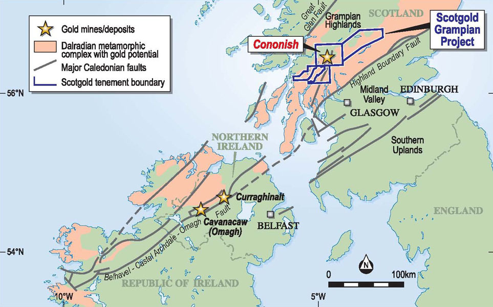
Scotgold Resources exploration project is located in the Grampian Highlands of mid-western Scotland. The Cononish gold and silver deposit forms the core economic basis of the Company’s Grampian Project. The deposit is located on Cononish Farm within the north-western extremity of the Loch Lomond and Trossachs National Park and lies about 90km northwest of Glasgow.
Within Scotland, the large tectonic block known as the Grampian Highlands, bounded by the Great Glen Fault to the northwest and the Highland Boundary Fault to the southeast, is highly prospective for gold and base metals. This terrane, which consists mostly of metasediments and volcanics of Dalradian age, is a direct continuation of the Dalradian gold province of Northern Ireland which hosts the Curraghinalt and Cavanacaw gold deposits.
Within the SW Grampian Highlands is the Tyndrum Mineral Field, a historic mining area which contains several vein-hosted deposits of base metals, including lead, copper and zinc. The best known of these is the historic Tyndrum group of lead mines, which were discovered in 1741 and intermittently produced lead for more than a century. Less commonly some veins also contain gold and by far the most important example to date is the Cononish vein-hosted gold and silver deposit situated about 4km SSW of Tyndrum.
Previous exploration has also identified the Tyndrum-Glen Fyne Fault - one of the major fault structures of the Grampian domain - as a zone of significant potential for lode-hosted gold mineralisation in the Glen Fyne area. Additionally there is also scope for new precious metal and base metal discoveries through the identification of geological settings which, elsewhere in the world, host significant metalliferous deposits. The British Geological Survey (BGS), which has completed geochemical surveys over the entire area held by Scotgold, has repeatedly expressed the view that there are significant metalliferous deposits yet to be discovered in the Dalradian of Scotland.
In November 2007 Scotgold’s applications for exploration licences for gold and silver between Craignure in the southwest and Pitlochry in the northeast were granted. The recently granted exploration licences cover an area of about 2,200 km2 and include much of the prospective Dalradian Supergroup.
1. THE CONONISH GOLD AND SILVER DEPOSIT
 Map 2 - Click to enlarge Map 2 - Click to enlarge |
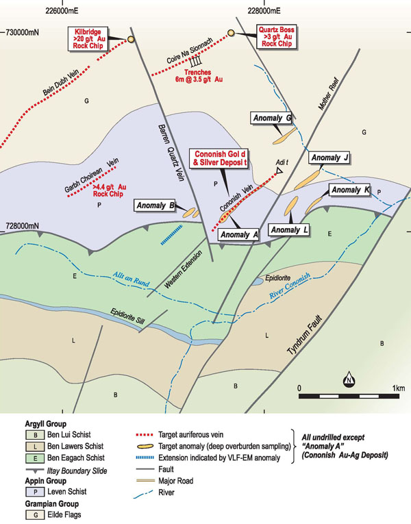
The Cononish gold and silver vein is hosted by a meta-sedimentary sequence of pelites, psammites and calcareous rocks of the Appin and Argyll groups belonging to the Dalradian Supergroup. The gold and silver occurs within a steeply-dipping quartz vein which is up to 8.3m wide and has an average width of about 2m. It has a known vertical dimension of about 500m and it can be traced along strike for more than 1km.
The Cononish gold and silver deposit was delineated by diamond drilling carried out between 1985 and 1988 and an underground development program was commenced in 1990. A total of 1280m of underground adit development was also completed, of which 590m was driven on the vein.
The best intercepts from the diamond drilling included:
| Hole Number | Easting | Northing | From (m) | To (m) | Intersection Width (m) |
Gold (g/t) (uncut) |
Silver (g/t) |
|---|---|---|---|---|---|---|---|
| CF87-07 | 11058.07 | 10865.68 | 161.85 | 165.50 | 3.65 | 30.95 | 102.90 |
| CF87-14 | 10802.66 | 10944.91 | 70.73 | 74.60 | 3.87 | 38.08 | 101.20 |
| CF87-24 | 10690.56 | 10922.39 | 107.23 | 120.72 | 13.49 | 29.26 | 117.27 |
| including | 107.23 | 113.17 | 5.94 | 61.77 | 252.01 | ||
| CF87-26 | 10750.01 | 10926.50 | 91.04 | 103.40 | 12.36 | 6.93 | 18.35 |
| CF88-03 | 10591.47 | 10903.84 | 155.57 | 168.16 | 12.59 | 9.61 | 34.89 |
| CF87-10 | 10915.98 | 11123.98 | 104.81 | 106.44 | 1.63 | 63.03 | 367.16 |
| CF87-03 | 10968.44 | 11193.01 | 59.20 | 61.38 | 2.18 | 23.76 | 112.05 |
| CF88-19 | 10849.94 | 10858.10 | 175.21 | 179.86 | 4.65 | 20.40 | 72.12 |
| CF90-08 | 10775.75 | 10923.44 | 91.55 | 93.79 | 2.24 | 50.20 | 345.09 |
| CF88-07 | 10803.61 | 10846.48 | 204.50 | 207.50 | 3.20 | 31.11 | 72.84 |
| CF90-07 | 10850.24 | 10927.46 | 83.98 | 87.12 | 3.14 | 13.31 | 32.38 |
JORC Code Compliant Resource
- Measured, Indicated and Inferred Mineral Resource categories total 154,000 ounces of gold and 589,000 ounces of silver (using 3.5g/t gold cut off)
- Snowden notes: “…there is strong potential to prove up further resources close to mine (within a few kilometres). This is likely to be in the region of 160,000 to 320,000 ounces of gold.”
Snowden Mining Industry Consultants Ltd (“Snowden”) has completed an independent JORC compliant resource report (8.3Mb) for the Company’s Gold Project at Cononish in the Grampian Highlands of mid-western Scotland.
The following information is summarized for the Snowden report, which was completed by Dr Simon Dominy and Dr Ian Platten of Snowden’s London Office. The complete report will be available for viewing on the Company’s website within 30 days of this ASX Release.
Geology and Mineralization
The Cononish mine comprises a gold-silver mineralized narrow quartz-vein system, the Cononish Vein, which has been trenched, diamond drilled and developed underground along one horizon.
The Cononish Vein is a steep, narrow (6m) vein system trending NE-SE and emplaced in Late Proterozoic metasediments of the Caledonides mobile belt. It shows brittle style deformation and completely postdates metamorphism and associated Caledonian foliations. Quartz veining is associated with the Tyndrum Fault, one of a set of NE-SW trending, left lateral, faults characterizing the Scottish Highlands. The vein system was emplaced during the late to post-tectonic (late Silurian to early Devonian) episode of granitoid intrusion in the Grampian Highlands.
Gold occurs as electrum and some minor amounts of native gold, silver occurs additionally as minor tellurides and native metal. The gold/electrum is fine-grained, generally <100 µm in size. Visible gold up to 1,000 µm to 2,000 µm in size is rare. Assay data suggests that gold and silver is spatially associated with sulphides in the quartz. The main sulphide is pyrite, but galena, chalcopyrite and sphalerite occur in small amounts.
Electrum and/or gold occur with galena in fractures in the pyrite and associated with the contacts between galena and pyrite grains. Some very fine-grained (<20 µm) native gold occurs within the pyrite
Data
The Cononish resource estimate is based upon diamond drillhole and adit face sample data collected in the 1980’s. Most of the core, all core logs, face sheets, geological maps and assay certificates are held by Scotgold. Snowden was able to review all the data and found it to be of an acceptable quality for resource estimation. Vein geology was validated through underground visits to the Cononish Adit. Sampling, QAQC and sample collection methods were of an acceptable quality
Resource Estimation
A polygonal and weighted average based resource estimate was undertaken for both gold and silver. This was preceded by statistical analysis of the grade data.
Statistical analysis indicates that the majority of the gold and silver is located within the quartz vein domain, with a lesser amount in the wallrocks. Top-cut of 70 g/t gold and 200 g/t silver were applied to all assay intervals prior to compositing for estimation.
With the current sustained increase in gold and silver prices to over US$800/oz gold and $15/oz silver, and combined with the potential premium on sales on branded ‘Scottish Gold’ jewellery. Snowden believes that resources of a grade of 3.5 g/t gold or above (effective breakeven cut-off grade) have a reasonable prospect for economic extraction. The resource was estimated using a minimum mining width of 1.2 m, giving a minimum metal accumulation cut-off of 4.2 m.g/t gold. At this level, it was found that the Cononish Vein has a payability of 85% (based on analysis of the close-spaced adit samples).
Resource Classification
The Cononish Main Vein resource was classified into the Measured, Indicated and Inferred Mineral Resource classes based on the JORC 2004 Code (Tables 1.1 and 1.2). It should be noted that Mineral Resources are not Ore Reserves, and thus do not have a demonstrated economic viability. A preliminary economic analysis was undertaken to show the likelihood of the Mineral Resources having ‘reasonable prospects for eventual extraction’.
The resource was defined on the basis of a manually defined boundary defining the limit of drilling and development. Outside this limit the drilling grid is too sparse or absent to allow the definition of resources with any confidence.
Conclusions
Cononish has the potential to be an economic, small, high-grade, narrow vein underground mining operation producing between 20,000 to 30,000 ounces of gold per annum. There is some potential for increased gold grade locally at Cononish, due to a high nugget effect and an information effect due to sparse drilling in areas of the Cononish Vein. There is some potential for increased gold grade locally at Cononish, due to a high nugget effect and an information effect due to sparse drilling in areas of the Cononish Vein.
Snowden also believes that there is strong potential to prove up further resources close to mine (within a few kilometres). This is likely to be in the region of 160,000 to 320,000 ounces of gold. Similarly there is also strong potential to prove up resources within Scotgold Resources’ licence areas, along the regional Tyndrum and Loch Tay Fault Zones, generally within 70 km of the Cononish site.
| Classification | Tonnes (t) | Grade (g/t) | Ounces (oz) | ||
|---|---|---|---|---|---|
| Gold | Silver | Gold | Silver | ||
| Measured | 60,000 | 12.7 | 55.1 | 25,000 | 107,000 |
| Indicated | 72,000 | 11.8 | 48.2 | 28,000 | 112,000 |
| Inferred | 431,000 | 8.9 | 33.5 | 124,000 | 464,000 |
| Classification | Tonnes (t) | Grade (g/t) | Ounces (oz) | ||
|---|---|---|---|---|---|
| Gold | Silver | Gold | Silver | ||
| Measured | 53,000 | 17.9 | 75.0 | 31,000 | 128,000 |
| Indicated | 63,000 | 10.1 | 42.2 | 20,000 | 85,000 |
| Inferred | 285,000 | 11.2 | 41.0 | 103,000 | 376,000 |
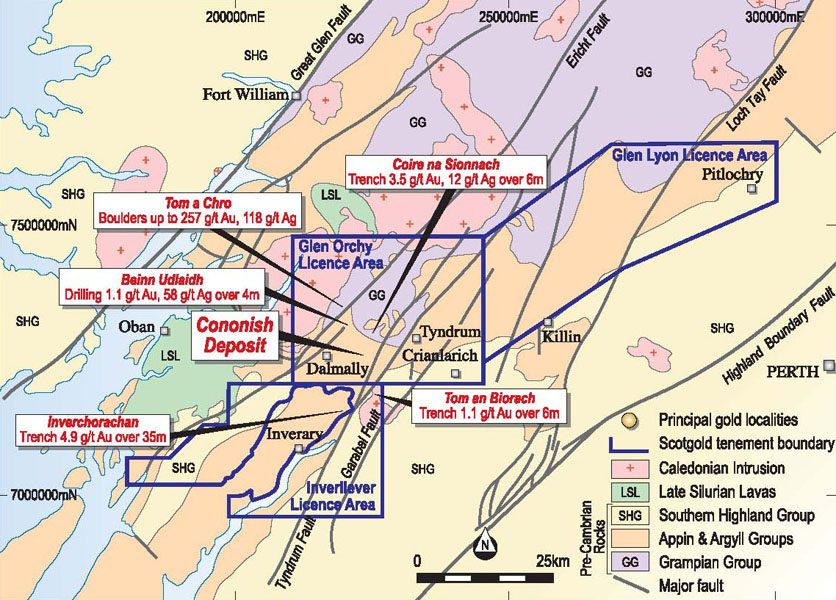
2. EXPLORATION TARGETS NEAR CONONISH
The most favoured structures for gold mineralisation in the Cononish area are the east northeasterly-trending quartz veins including the Cononish vein itself, Coire na Sionnach, Garbh Choirean, and Beinn Dubh, together with several elongate geochemical soil anomalies including Anomaly B. Together these veins and elongate anomalies form a swarm of parallel structures and are interpreted to be of the same age. In brief the exploration targets associated with these structures and anomalies are:
 Map 3 - Click to enlarge Map 3 - Click to enlarge |
- Cononish Deeps - mineralisation at Cononish is open at depth. Potential to significantly increase the extent of the presently known mineralisation at Cononish by deeper drilling.
- Anomaly B – displaced structure; deep overburden geochemical gold anomaly coincident with a VLF-EM anomaly; sample of ‘A mineralisation’ float assayed 8.72 g/t gold in this area. An important target for the discovery of additional gold mineralisation close to Cononish.
- Coire Na Sionnach - rock chip samples with values up to 6 g/t gold; best two trenches: 5.0m @ 3.6 g/t gold, 8.6 g/t silver and 6.0m @ 3.5 g/t gold, 12.1 g/t silver. Ready for immediate drill testing and is regarded as a high priority target.
- Bein Dubh Vein – an offset quartz vein in which a rock chip assayed more than 20g/t gold. To be tested by more extensive rock chip sampling.
- Garbh Choirean Vein - parallel to the Cononish and Coire na Sionnach Veins; only partially tested. To be tested by additional sampling.
- Deep Overburden Gold Anomalies - anomalies B, G, J, K, and L in the vicinity of the Cononish deposit are elongate and sub-parallel to the mineralised quartz veins and may reflect presence of underlying auriferous quartz veins. Represent targets for further investigation.
3. EXPLORATION TARGETS ELSEWHERE IN THE TYNDRUM MINERAL FIELD
Many other promising prospects which occur within a few kilometres of Cononish are comprehensively documented in Scotgold’s newly-acquired database. These prospects could provide additional mineralisation to supplement any future gold mining operation at Cononish itself. Several of these are advanced prospects which will be explored as a priority. In brief the targets are:
- Tom A Chro –
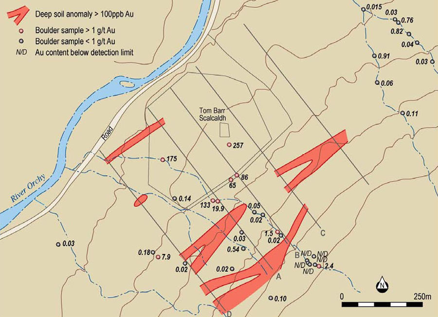
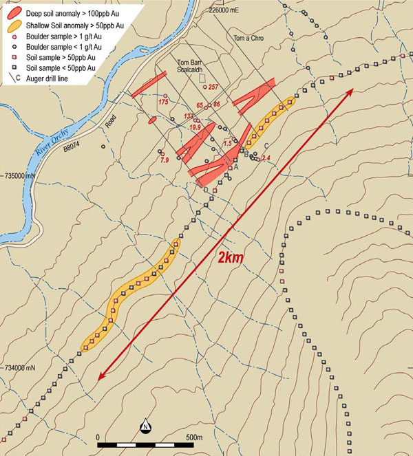
Exceptionally high gold and high silver values were obtained from rock chip sampling at Tom a Chro in 1985 by Fynegold Exploration Ltd. The highest gold value of 257 g/t gold was a rock chip from an in situ vein but most of the anomalous samples were boulders of uncertain provenance. The prospect is on the north-facing slope of Ben Udlaidh and some downhill migration of the boulders may have occurred. The auriferous boulders occur within an area measuring approximately 750m by 250m with the long axis oriented downslope.
Table 2: Results of rock chip sampling, Tom a Chro, 1985 Sample number Type of sample Gold (g/t) Silver (g/t) 6951 Boulder 175 71.5 11176 Rock chip from vein 257 118 6952 Boulder 65.4 30 5872 Boulder 86.1 23.3 5857 Boulder 133.7 56.3 5871 Boulder 25.4 0 5859 Boulder 2.4 1.1 18823 Stream sediment 19.9 N/A
As part of Scotgold Resources’ review of the extensive database acquired from Fynegold, The Company has now located and processed the results of two soil sampling surveys carried out at Tom a Chro in 1986.
 Map 4 - Click to enlarge Map 4 - Click to enlarge |
In the first survey, soil samples were obtained along five grid lines in the vicinity of the boulders, using a power auger to reach or approach the soil/bedrock interface. The 100ppb gold contour delineates several sub-parallel zones of gold anomalism over a distance of over 600 metres, with a maximum gold value of 2.38 g/t gold. Due to the limited extent of the auger sampling grid the anomalous zones remain open in three directions.
The results of the first survey indicate that the bedrock is anomalous in the immediate vicinity of the surface boulders and these highly-anomalous boulders may therefore relate to the underlying rocks.
The second soil survey was made by taking samples near the surface and was part of a regional soil sampling program along single geographic contours (‘contour sampling’), in this case the 250m contour.
 Map 5 - Click to enlarge Map 5 - Click to enlarge |
In the second (shallow) soil survey, gold values above an arbitrary cut-off of 50ppb delineate two elongate anomalous zones extending over hundreds of metres in the vicinity of Tom a Chro. These results must be interpreted with caution, particularly the shape and extent of the anomalies, as there is limited information outside the sampled contour.
The shallow soil contour anomalies overlap the deep soil auger anomalies but have a considerably longer strike length. Together the two sets of soil data suggest a 2km-long mineralised structure trending NE-SW, parallel to the mineralised vein which hosts the Cononish deposit located about 7 km to the south.
This information considerably upgrades the importance of Tom a Chro. The prospect is now ready for immediate drill testing and it is planned to do this as soon as land access and planning permission (if necessary) are secured.
- Beinn Udlaidh –
an auriferous quartz vein sub-parallel to the Cononish Vein which intersects different rocks to those that host Cononish; initial trenching yielded 10.27 g/t gold and 241 g/t silver over 2.3m within a hematitically-altered gossanous quartz vein; eleven holes drilled gave a best result of 4m @ 1.1 g/t gold and 58.4 g/t silver at a depth of 35m; low grades ascribed to extensive and deep weathering of the rock accompanied by hematisation of the quartz. The ENE trend of the vein at Beinn Udlaidh, its pink coloration and the widespread gold anomalies from surface sampling and from drilling suggest that further drilling should be carried out at this locality.
4. REGIONAL EXPLORATION TARGETS
Through its acquisition of Fynegold, Scotgold Resources now has a comprehensive database of information covering a large region of the SW Grampian Highlands and includes soil sampling, rock chip sampling, deep overburden sampling, stream sediment sampling (including the collection of panned concentrates), and geophysical surveys including VLF-EM, gravity and aeromagnetic surveys. The database reveals many specific prospects on the basis of anomalous geochemistry, geophysics and geological setting and many of these merit immediate follow up.
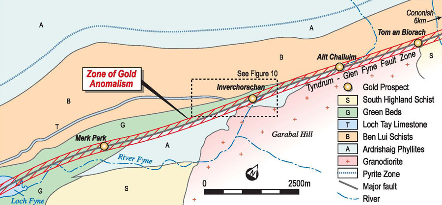
The highest priority for exploration will be given to the outstanding series of prospects within the Tyndrum Fault Zone in Glen Fyne. Within Glen Fyne, which lies along the southern extension of the Tyndrum Fault, a linear zone of exploration potential has been identified. In this narrow valley the Tyndrum Fault intersects Green Beds of the Southern Highland Group and Ardrishaig Phyllite of the Appin Group near their contact with a granodiorite intrusion of Caledonian age. Here the Tyndrum Fault has produced a tectonic corridor in which all of these rock types are commonly strongly sheared, altered and pyritic, and contain extensive linear zones of elevated gold values. This structural corridor within the Tyndrum Fault Zone in Glen Fyne is considered to have exceptional exploration merit.
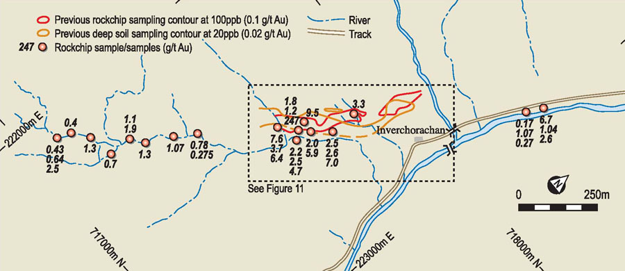
An elongate zone of geochemical anomalism parallel to the axis of Glen Fyne was first recognised from BGS stream sediment sampling, based on Cu, Pb and Zn assays. Subsequent regional rock chip sampling in this area for gold outlined a comparable elongate zone approximately 4.5km long on the basis of gold values exceeding 200 ppb gold (0.2 g/t gold). The highest value in this survey was 1.08 g/t gold and silver values were generally low.
The key exploration targets are at Inverchorachan and Tom an Biorach:
 Map 6 - Click to enlarge Map 6 - Click to enlarge |
 Map 7 - Click to enlarge Map 7 - Click to enlarge |
- Inverchorachan –
initial rock chip sampling program included one 500g grab sample which assayed 277,000 ppb (277 g/t gold) and a 2kg composite chip sample which assayed 9.4 g/t gold, plus numerous other high gold assays. Subsequent rock chip and deep soil sampling programs identified an anomalous zone about 500m long and 50m wide oriented approximately northeast-southwest. Four trenches excavated within anomalous zone were highly anomalous in gold; one metre panel sampling along one trench (about 35m long) gave exceptionally consistent gold grades, with 85% of samples in the range 1 to 6 g/t gold. Detailed geological mapping and sampling indicates that several rock types here contain gold, pointing to lode-style mineralization within a wide shear zone in contrast to gold mineralization confined to a discrete quartz vein as at Cononish. The 500m long anomalous zone at Inverchorachan is ready to drill and is a high priority drilling target.
- Tom An Biorach –
a deep soil anomaly defined by the 25 ppb gold contour occurs as an elongate zone of gold anomalism nearly 500m long approximately co-linear with Inverchorachan; best trench sampling results were 6m averaging 1.14 g/t gold, with the mineralization occurring within chloritic-altered quartzite and Green Beds containing abundant pyrite estimated at up to 30%. This well-defined anomaly at Tom An Biorach is ready for drill testing and the target zone is similar in size to Inverchorachan.
5. OTHER REGIONAL TARGETS
The entire Crown Licence area currently held by Scotgold has been previously sampled by the BGS as part of a nationwide program of stream sediment sampling which commenced in 1969. The samples were assayed for a wide range of elements and the data is available as regional atlases showing areas of geochemical anomalism.
In 1989 Canadian consulting group Watts, Griffis and McOuat (WGM) carried out nondestructive neutron activation analysis of 2260 BGS samples covering much of Scotgold’s licence areas for a total of 27 elements per sample. This geochemical data, combined with their own, enabled WGM to identify five anomalous areas and eleven regional exploration targets, many of which appear to be related to northeast-southwest trending structures.
In addition:
- The geological setting around Aberfeldy has been compared to that of the giant Hemlo gold deposit in Canada, which was discovered in 1981.
- Researchers have also suggested that the Middle Dalradian with its extensive stratigraphic Pyritic Zone, high level igneous intrusives, widespread sericite alteration, and major structures, could be a good regional target for stratabound gold mineralisation.
- The Dalradian is acknowledged as a Sedex/volcanogenic-hosted massive sulphide (VMS) environment with a series of second- and third-order sedimentary basins.
Initially the Company intends to focus its exploration effort in areas of high immediate promise such as Cononish and Glen Fyne, but a systematic review of the literature and other databases combined with some field work will be used to progressively identify other targets in the Tyndrum-Pitlochry section of the Dalradian metamorphic belt.